TO VISIT
LAKE Bracciano (Lacus Sabatinus) And 'certainly the most famous lake of Lazio, only second in size behind in Bolsena is the eighth in Italy. With its 57.5 square km is the largest in the province of Rome by extension, but only the second for depth with its 160 meters. Almost circular, housed in a set of cavity crater mountains Sabatini for a length of 9.3 km and a width of 8.7, and is powered by a small watershed and groundwater. Its surroundings are a set of natural beauty, archaeological evidence linked to the historical heritage, make the lake only the center of a tourist complex of exceptional value and perhaps still little known. Moreover as for the rest of Lazio, the proximity of Rome is a bit 'overshadow everything else, even if the "lake of Rome", the ancient Sabatinus lacus was known since the time of the Etruscans.
WHAT TO SEE: Along its 31.5 km of perimeter lie the 3 coastal towns, Bracciano, Anguillara and Trevignano Romano each with its own character and each worth a visit. Bracciano is certainly the best known, best known for the presence of the imposing Orsini castle overlooking the waters of the lake and the site shows traces of settlements since the times of the Etruscans. Not far away are finally Vigna di Valle, a town best known for hosting the Air Military Historical Museum.
THE LAKE: The area north of the Province of Rome offers a few kilometers from the capital, a variety of cultural and artistic aspects that touch almost the entire span of the civilization of our country; by the testimonies of pre-Roman Italic peoples, such as the Etruscans, to the many medieval towns that welcomed the fugitives on their hills of the countries affected by the barbaric invasions, the monasteries, hermitages in the quiet of the woods to the castles of the Roman patricians, who with their towers and ramparts still stand out on the landscape and are visited by many tourists. All this is immersed in a landscape still intact, allowing you to visit the area between Cerveteri and Lake Bracciano, nature reserves and parks, lakes and rivers surrounded by a campaign carefully cultivated that offers typical and genuine. And so the itinerary historical and natural it joins that of taste, to rediscover, beside the monuments of great importance and recall, ancient flavors, in an environment of great richness and variety. Lake Bracciano (Sabatino also called) is almost circular (diameter about 9 kilometers deep in the center 170 meters) and occupies a large volcanic depression (57 sq km area, perimeter Km 31.5) The hillside location (288 m above sea level) and its relative proximity to the Tyrrhenian coast favor a mild climate throughout the year. In this part of northern Latium nature it has so generously dispensed with an incredible variety of fauna and flora. In the lake abound many species of fish: eels, pike, tench, whitefish, carp, perch. Among the reeds, in the creeks, resting migratory birds, coots, geese. In the nearby woods, among oaks, chestnut trees, olive trees, oaks, willows, poplars and elms, we discover wild boars, badgers, porcupines and weasels. The man chose to stop at the shores of this lovely lake in prehistoric times, as attested by the discovery of remains of dwelling villages in the area of Vicarello, near Trevignano. Following was the site of Etruscan settlements, today emerged from excavations such as those relating to the location of Ricostano, Olivetella, Columns.
In Roman times the lake was called "Sabatinus Lacus" because it was formed in the caldera of the ancient volcano Sabatino. Besides being a magnificent natural scenery and popular tourist destination, the lake is also an important site for water sports and hobby and mini sightseeing cruises with stopovers in the picturesque town of Trevignano and Anguillara.
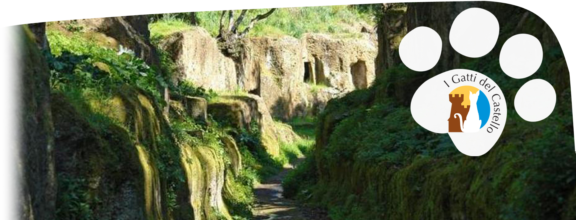
MONTERANO ETRUSCA:
Like many Etruscan cities, Monterano was built on top of a hill, in an extraordinary defense and impregnable. The slopes are about one hundred meters high, are steep and sometimes above the valley floor, making it extremely difficult to reach the top. The work of the Etruscans made, over the centuries, the village even more defensible through, among other things, roads carved into the tufa, very easy to control, and building work in essential complement to the course provided by the morphology of the place. The people that probably roamed the countryside and valleys monteranesi found in the plateau the ideal place to concentrate to melt the most equipped urban area.
The appearance, structure and monuments of Etruscan Monterano are largely unknown due to the lack of systematic archaeological research, to the perishable nature of the material used in construction and for the overlap in the same place of successive settlements. The Etruscan building techniques are not allowed to leave the remains consistent over the centuries, as for homes and temples were used wood and clay, while the stone was used only for the city walls, the doors and the graves.
At present, therefore, the appearance of the Etruscan city can only be guessed, referring to the general knowledge of this civilization. The apartment buildings had to be low and side by side, rested on solid rock or on stone foundations. The walls were built of mud-brick or with frames of poles, reeds and branches covered with layers of clay. The hearth was against the wall or in the middle of the room.
The plateau there were no springs, the water was transported with an ingenious aqueduct from the plateau of Oriolo and stored in tanks dug into the rock. Just outside the town began to extend the vast necropolis, which is what is most important remains of the Etruscan. The oldest tombs are the ones closest to the village, while the average period, coinciding with the greatest prosperity, are the most distant. Finally, the last Etruscan tombs are found again in the vicinity of the city limits.
On the plateau of Palombara there are the remains of a second series of tombs that starting from the same plateau monteranese follow the route of an ancient Etruscan road and come to the village Pozzo Tufo. The necropolis richer, however, is the one that extends on the hill of the Banned. At two graves known, used for centuries by shepherds and farmers as shelter, it has been given by the popular tradition the name of Grottino Banned Cave and Tobacco.
To reach the ruins of Monterano currently must follow paths inaccessible, but the situation was very different in the Etruscan period, when a roadway network driveway linking the thriving town with other towns and the surrounding countryside. The most important road was directed at Caere, the current Cerveteri, the regional capital. Just outside the town the way down to the Cavone, in a gorge cut into the rock, to the valley of Bicione. After the stream, he climbed the hill Madonella in the bottleneck of Canalicchio and, after crossing to twenty kilometers the current areas of Manzanita and Castel Giuliano, reached its destination.
A second road was heading towards another big city of Etruria, Tarquinia. Down the hill dug out of tufa and crossed the river Mignone with a wooden bridge, not unlike that used a few decades ago, and then continued on the right bank of the river in the direction of the city.
You can groped a description of the economic and social life of the Etruscan Monterano according to ancient historiography and publications on local archaeological discoveries. The main economic resources of the city were linked to agricultural production (wheat, wine, oil), livestock, the cutting of forests and exploitation of mineral resources (iron). He did not have to miss a certain craft, such as metal processing, wood, leather, ceramics and weaving of wool. Of these products was a significant trade, mainly with Caere, the leading city which remained tied Monterano is expanding, both in decline.
The improvement of agriculture and crafts, from earlier primitive settlements, introduced a greater division of labor that accentuated social differences. The adoption of writing, the preserve of the few, and the religious organization formed two powerful instruments of control over the lower classes: the wealth went concentrating in a few hands, and the aristocrats, in exchange for protection, dominated the middle class and lower, while the serfs and slaves were virtually deprived of civil rights. After the conquest, the Romans quickly erased the social structure Etruscan replacing it with another, less rigid, found space where the middle classes of the rich craftsmen and traders.
The territory of Stigliano is particularly rich in archaeological remains, since prehistoric times. The Etruscans founded a village, as evidenced by the necropolis and ancient objects found therein. The Etruscan settlement, probably located in the woods north of the spa, was built at the road that joined Caere Tarquinia through Castel Giuliano, the Pietrische and middle valley of Mignone.
The presence of healthy waters and the passion of the Romans for the spa Stigliano saved from decay that had fallen the Etruscan centers inland after the Roman conquest. While Monterano was being depopulated, Stigliano entered the happiest time in its history. Flowering economic and cultural center of the Roman Empire is evidenced mainly from the remains of a paved road, the Selciatella, and the ruins of the baths and the temple dedicated to the god Apollo, the healer of diseases. The name of the village was in fact Roman Aquae Apollinares.
The Selciatella connected the baths of Stigliano, with the important Via Clodia. Along this ancient road, hit the remains of an impressive work of road construction, which allowed all Selciatella to cross a ditch and its valley, the Devil's Bridge. The viaduct is about 90 meters long, 6 wide and 9 high and exceeds the ditch with a single arch, whose light is almost 7 meters. And 'it built in large blocks of lava stone that reach up to 2 meters long, fitted together without mortar dry connection. The dating of the monument is not known. In all likelihood, an initial examination of the construction techniques that reveal among other clear influences Etruscan, the bridge dates from the late Republican period, in the first century BC
After the conquest, the Romans organized the territory of the State of Caere according to political, economic and commercial Rome. The mountain region Sabatini was involved in a new wave of traffic that followed the route of the Via Clodia, the road that connected Rome with Lake Bracciano and passed to the current territories of Manzanita and Oriolo. Monteranese territory, cut off from the new road, was linked to the Roman road network in part, through Selciatella that reached the baths of Stigliano. From the second century BC, the region was the subject of intensive Roman colonization. With the growth of the settlements was felt necessary to provide for an urban center adequately equipped small rural villages and hamlets scattered throughout the countryside. Took so important the town built along the Via Clodia, towards the hill of San Liberato, on Lake Bracciano, which was given the name Forum Clodii.
CERVETERI, LA NECROPOLIS OF BANDITACCIA: Caere was one of the richest and most prestigious Etruscan cities. His wealth stemmed from the intense commercial activity exercised by all the countries of the Mediterranean sea with its three ports: Pyrgi, Punicum and Alsium, equivalent to the current Santa Severa, Santa Marinella and Palo Laziale. The heyday of Caere, witnessed by the monumentality of its necropolis and the richness of the artefacts found, was reached between the seventh and fifth centuries BC; from the end of the fifth century began to suffer the crisis that gripped the whole of Etruria sea because of the rising commercial and military power of Syracuse. In 374 BC the fleet of Dionysius, tyrant of Syracuse, seized the Temple of Pyrgi and destroyed it, then came the Romans who, with their power Caere finally subdued in 358 BC The monument of Banditaccia, partially excavated and restored over the last fifty years, is one of the most impressive archaeological landscapes in the world, not surprisingly has been recently recognized by UNESCO as World Heritage City. The main interest is due to the plant planning of this city of the dead, which clearly reflects that of the city of the living. The original to be found in the cemetery of Villanova Quarry of pozzolana. The tombs were arranged along a main road, which was to unite Caere to the other centers, clearly visible in the area known as the old fence, where they are even visible traces of wagon wheels running through it, and along other smaller streets that intersected. This is the area fenced and equipped for the visit which is accessed by paying ticket. The mounds have bases in rocks and stones of various sizes, some with colossal 30 meters or more in diameter, such as "Mengarelli" and "Colonel" within which there are one or more groups of tombs carved into the tuff imitating the arrangement of the interior spaces of private homes: creating doors, shaped windows, columns, pillars, beamed and coffered ceilings, furniture, chairs, beds funeral. All the graves, dug at a considerable depth, had a external arrangement, made in part with the excavation of the dromos access and yards in front of this, and partly by creating walls block. All of these rooms appear remains only occasionally, since excavations have mainly tried to make accessible the burial chambers. The mounds oldest, dated within the sixth century. BC, stand quite messily on the ground, and are connected to massive funeral altars for worship. These major structures are surrounded by numerous graves, mounds minor, underground rooms. It is thought that he may interpret this feature as the post mortem resubmission of the political system of that time: a class magnate, soaring politically and economically, surrounded by his patronage apparatus, formed by families and individuals of different economic and social levels. During the sixth century. B.C. organizational models applied in the city, with the logical distribution of the roads, the planning of public and private buildings, are adopted even in cemeteries. Along the main road, already densely occupied by mounds of various sizes, open cross streets; other monuments are excavated bodies quadrangular, with facades open on sepulchral ways straight intersecting at right angles. The external walls are adorned with architectural frames very simple and there are hints of polychrome decorations, obtained by alternating rows of tuff and nenfro.
ITINERARY BRACCIANO with the spectacular Castle (1480); hence turning right along the lake, you pass Bagni of Vicarello, from whom are the ruins of ancient Roman villas and, 12 km away. Trevignano Romano, where you leave the lake and proceeds, with 13 km. to the north, for SUTRI; here you go to Monterosi heading (9 km. left) towards NEPI, with beautiful fortress of the Borgias, which descend from the waters of a waterfall: one of the most famous landmarks in the Italian painting, above all foreign, of 600 and 700 . In view of the imposing Aqueduct century, it moves to Civita Castellana. After 3 km. path in beautiful scenery of steep hills, you come to the Basilica of Castel Sant'Elia (sec. XI) strong Romanesque architecture with Byzantine frescoes of the eleventh century. Hence we are soon to Civita Castellana
- Castle of Orsini Odescalchi: www.odescalchi.it
- Town of Bracciano: www.comune.bracciano.rm.it
Air Force Museum: Among the most 'largest in Europe both in size and as the quality and quantity of material exposed. Vigna di Valle, phone +390699801114 - http://www.aeronautica.difesa.it/museovdv/Pagine/default.aspx
EVENTS:
BRACCIANO
- Friday: "The Passion"
- May 1: Corpus Flower Festival for the town's streets
- Late July: Feast of the Products of Bracciano
- August: relive the historic center
- Last weekend of August: Siege, re-enactment of the siege of the Borgias in 1501
- Second weekend of September: Holy Mary Mother of the Church Location in Vigna di Valle
ANGUILLARA SABAZIA
- June: Corpus Christi procession with floral display in the streets of the town
- August: Music and entertainment in the gardens of the Tower Medieval
- December: Nativity under the waters of the lake and underwater Procession
TREVIGNANO ROMANO
- May 20: Feast of San Bernardino with marinated fish festival
- July 15 to August 20: Summer Trevignanese
- June-August: Cittadella del Corto. Film review
- August 15: Feast of the Assumption with procession of boats on the lake
CANALE MONTERANO
Canale Monterano (near Bracciano)
A few kilometers from Rome, the nature of southern and a landscape shaped by ancient volcanoes meet with history in the Regional Reserve of Canale Monterano
